Class = 2
Structure_name = Andorra
Country = Eastern Pyrenees
Continent_Ocean = Eu
Lat = 42.520000°
Lon = 1.550000°
Diameter_km = 17
Age_Ma = MZ-KZ
Notes =http://impact.ucoz.com/KMZ2/Andorra.kmz
http://labmpg.sscc.ru/Impact/ab534.html- Vishnevsky S.A. (2001). Andorra Basin: a possiable heavily eroded
impact site?. Meteorit. and Planet. Sci., Vol.36, No.9, P. A215
- Вишневский С.А. (2007). Астроблемы. , Новосибирск
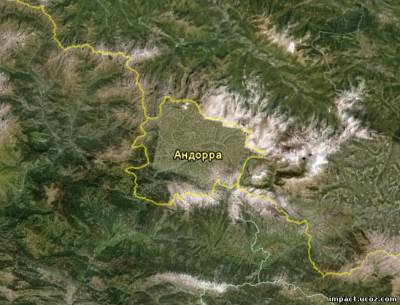
Спутниковая фотография кратера из Google Earth.
Обзор статей:
A rounded basin of 16 - 18 km in diameter, with center co-ordinates 1
33'E and 42 31'N is present in the Eastern Pyrenees; a major part of
the Andorra State is localized within this basin. It is surrounded by
mountain ridges of up to +2,700-3,000 m a.s.l. along its western,
northern, eastern and south-eastern sides. To south-west, the basin is
opened along the Valira river valley. In spite of the numerous river
valley downcuttings and a complex topography, the basin, in a whole, has
a relatively flat bottom but step slopes; these slopes turn gradually
into surrounding mountains. The river net (Valira-river and its
tributaries) forms a radial centripetal system within the basin. Owing
to this pattern, this net differs from other river systems of the
Eastern Pyrenees. Commonly, other rivers of the region have a plume- or
wing-like branching pattern, which is a typical feature for the eroding
highlands.
In a geological respect, the region described is made up of a broad
number of formations of various age. Like the Eastern Pyrenees in a
whole, these formations include old crystalline rocks (gneisses and mica
gneisses), Paleozoic (Cambrian, Silurian, Devonian, Carboniferous and
Permian members) and Mesozoic (Triassic and Jurassic members) rocks. All
the supracrustal formations are folded up into a complex system of
anticlinal and synclinal srtuctures of sublatitudal extent. Blocks of
crystalline rocks and intrusions of alkaline and amphibole granites take
also part in geologic structure of the area. Loose Cenozoic sediments
of various ages (Oligocene to Pleistocene) are also present within
intermountain depressions and river valleys. The Andorra Basin has a
clear superimposing origin in respect to the regional geologic
structures. Its shape does not correlate with the sublatitudal extent of
these structures. Together with its morphology, there is another
feature of the Basin, which can attract attention. Being the
erosionresistant bodies, the granite massifs of the Pyrenees usually
play an important relief-forming role and form the highest points of the
given mountain ridge. However, an offshoot of a large granite massif,
which extends into a central part of the Basin from the east, exhibits
anomalous low resistance to erosion and occupies the part of the Basin░s
bottom.
An isometric shape of the Andorra Basin and its clear superimposing
position in respect to the regional geologic structures, as well as a
radial centripetal pattern of the river net within, are of a special
interest. Author paid attention to this structure still in 1990, when a
spatial analyses of some regions of the globe was performed in order to
search for the possible impact structures. Anomalous low erosional
strength of granites inside the Basin is another point of the interest.
Based upon these features, there is a possibility to suppose, that the
Andorra Basin may be a heavily eroded impact structure of ~16-18 km in
diameter. Within such a supposition, a low resistance of granites within
the Basin can be explained as a result of shock brecciation. Based upon
stratigraphic and tectonic data, the age of the supposed impact
structure can be estimated as Mesozoic or Cenozoic.
(Vishnevsky S.A., 2001).
Округлая в целом наложенная впадина, игнорирующая субширотное
простирание складчатых геологических структур региона. Гидросеть в
пределах котловины обладает элементами радиально-центростремительной
системы, отличающейся от перисто-ветвящихся речных долин окружающих
территорий. Граниты, обнажающиеся в центральной пониженной части дна
котловины являются ей особенностью по сравнению с окружающими гранитными
телами, играющими важную рельефообразующую роль в регионе, слагая
наивысшие точки Пиренеев. Эти особенности позволяют считать котловину
Андорры возможной глубокоэродированной астроблемой мезо-кайнозойского
возраста, диаметром ~16-18 км, в осевой части которой сохранились
реликты подкратерной линзы брекчирования (в том числе и подвергшихся
денудации гранитов центральной части котловины),
потенциальноперспективной для поиска петрографических следов ударного
метаморфизма.
(Вишневский С.А., 2007).
| 